Home Home
  • Home
  • News
  • Sectors
    • City councils
    • Public authorities
    • Mobility and sustainability
    • Service networks
    • Companies and businesses
    • Logistics
  • Tools
    • Cercalia
    • enMapa
    • Recitty
    • Custom solutions
  • Contact
Contact

Breadcrumb

  1. Home
  2. City councils
  3. Castello city council

Castelló City Council

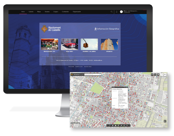
We have implemented a geographic viewer that enables the consultation of files and occupation of public thoroughfares

Castello
Image
castello

Castelló City Council

banner

What can be found there?

  • The implementation of the ArcGIS platform in the Council, which consists of the ArcGIS for Desktop Standard, ArcGIS for Server, Portal for ArcGIS and access to ArcGIS Online.
  • The preparation of geographic information, mainly files from the Management platform and publication in a map viewer accessed internally.
  • The configuration of a data entry form for high levels of occupation of public thoroughfares and its publication in the viewer, along with transportation layers (GTFS).
CONTACT
  • Barcelona Office
    Aragó 264 4, 08007 Barcelona
  • Girona Office
    Joaquim Botet Sisó 6, 17003 Girona
  • Madrid Office
    Paseo de la Habana 9-11, 28036 Madrid
  • +34 93 0172728
    [email protected]
  • TwitterYoutubeLinkedin
  • energia renovableEuroCertISOPymeInnovadora
SECTORS
  • City councils
  • Public authorities
  • Mobility and sustainability
  • Service networks
  • Companies and businesses
  • Logistics
NEXUS
  • News
  • Work with us
  • Cercalia
  • enMapa
  • reCitty
  • Contact
OTHERS
  • BusManager
  • Routing Reparto
  • Quality and safety policy
  • Cookies policy
  • Privacity policy
  • Social media policy
  • Legal advice
  • Home
  • News
  • Sectors
    • City councils
    • Public authorities
    • Mobility and sustainability
    • Service networks
    • Companies and businesses
    • Logistics
  • Tools
    • Cercalia
    • enMapa
    • Recitty
    • Custom solutions
  • Contact